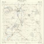
خريطة مفهرسة
Northamptonshire XIX.SW - OS Six-Inch Map

المؤسسة:National Library of Scotland
العنوان الكامل:Northamptonshire XIX.SW - OS Six-Inch Map
مصورة:1950
تاريخ النشر:1952
الناشر:Ordnance Survey
مقياس الخريطة:1:10 560

Northamptonshire XIX.SW - OS Six-Inch Map
1950
Ordnance Survey
1:11k

Northamptonshire XIX.SW - OS Six-Inch Map
1924
Ordnance Survey
1:11k

Northamptonshire XIX.SW - OS Six-Inch Map
1924
Ordnance Survey
1:11k

Northamptonshire XIX.SW - OS Six-Inch Map
1899
Ordnance Survey
1:11k

Northamptonshire XIX.SW - OS Six-Inch Map
1885
Ordnance Survey
1:11k

Northamptonshire XXVII.NW - OS Six-Inch Map
1950
Ordnance Survey
1:11k

Northamptonshire XXVII.NW - OS Six-Inch Map
1899
Ordnance Survey
1:11k

Northamptonshire XXVII.NW - OS Six-Inch Map
1899
Ordnance Survey
1:11k

Northamptonshire XXVII.NW - OS Six-Inch Map
1885
Ordnance Survey
1:11k
TL08 - OS 1:25,000 Provisional Series Map
1938
Ordnance Survey
1:25k