3D

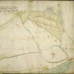
The platt of the Lowe Countrye att Calleys
This is a map of Calais, Franceand the surrounding area from the sea. It was drawn in October 1545 by Thomas Petit. Although not formally appointed as Surveyor of the works at Calais until February 1546 Petit was in the post by October 1545 after his predecessor John Burgate died, probably of plague. The map shows the environs of Calais, recording waterways and fortifications of the area. The town of Calais is shown with the castle to the right. The Rysebank tower with its distinctive triangular bastion is also depicted. The enlargement of the fort at Rysebank was one of the main areas of work during the building programme of the 1540’s. Newneham bridge is also shown. This controlled the causeway across the marches to the west of Calais and its sluice gates could be used to dam the Hammes River and flood the low country around the town .It was therefore a vital part of the defences.
The British LibraryPetit, Thomas
1545

