3D
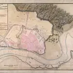
A Plan of Berwick upon Tweed
Plan of Berwick upon Tweed in Northumberland showing the High Street and the walls, bastions and other fortifications protecting the town. The town developed at the mouth of the River Tweed on the east coast and is the most northerly town in England. During the town’s history it changed hands many times between England and Scotland hence its heavy fortifications as shown on this plan. Berwick was granted special’ status and was of’ the Kingdom of England but not in it. This is one of many plans in the King George III Topographical collection showing 18th century fortresses.
The British Library1725