项目
社区
新闻
我的应用程序
我的地图
地图 奥兰治湾 (加利福尼亚州)
高级搜索
全部
私人
收藏夹
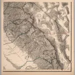
Topographical Map of Central California Together With a Part of Nevada, Sheet IV.
1873|Whitney, J.D.
1:380 160
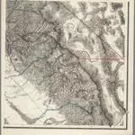
Topographical Map of Central California Together With a Part of Nevada, Sheet IV.
1873|Whitney, J.D.
1:380 160
Topographical Map of Central California Together With a Part of Nevada, Sheet IV.
1873|Whitney, J.D.
1:380 160
Composite: Topographical Map of Central California Together With a Part of Nevada, Sheets III-IV.
1873|Whitney, J.D.
1:380 160
The Central Part of the State of California.
1865|Poett, A.
1:253 440
Central California.
1866|Holdredge, Sterling M.
1:2 471 040
Map Of The San Joaquin, Sacramento And Tulare Valleys.
1873|United States. Congress
1:760 320
1600
1650
1700
1750
1800
1850
1900
1950
2000
历史
奥兰治湾 (加利福尼亚州)的老地图
在历史地图上发现 奥兰治湾 (加利福尼亚州) 的过去
奥兰治湾 (加利福尼亚州)的老地图
在历史地图上发现 奥兰治湾 (加利福尼亚州) 的过去
探索地图
发现历史
母区域
图莱里县
相关地点
© MapTiler
© OpenStreetMap
 1873|Whitney, J.D.1:380 160
 1873|Whitney, J.D.1:380 160
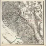 1873|Whitney, J.D.1:380 160
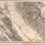 1873|Whitney, J.D.1:380 160
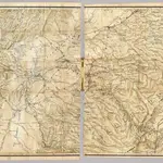 1865|Poett, A.1:253 440
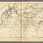 1866|Holdredge, Sterling M.1:2 471 040
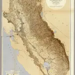 1873|United States. Congress1:760 320