خريطة مفهرسة
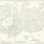
Hampshire and Isle of Wight XIX.14 (includes: Tunworth; Upton Gray; Weston Corbett) - 25 Inch Map
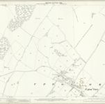

المؤسسة:National Library of Scotland
العنوان الكامل:Hampshire and Isle of Wight XIX.14 (includes: Tunworth; Upton Gray; Weston Corbett) - 25 Inch Map
مصورة:1894
تاريخ النشر:1896
الناشر:Ordnance Survey
مقياس الخريطة:1:2 500
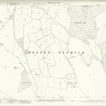
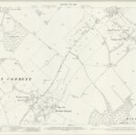
Hampshire and Isle of Wight XXVII.6 (includes: Herriard; Upton Gray; Weston Corbett; Weston Patrick) - 25 Inch Map
1909
Ordnance Survey
1:3k
Hampshire and Isle of Wight XXVII.6 (includes: Herriard; Upton Gray; Weston Corbett; Weston Patrick) - 25 Inch Map
1894
Ordnance Survey
1:3k
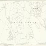
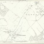
Hampshire and Isle of Wight XXVII.10 (includes: Herriard; Lasham; Shalden; Upton Gray; Weston Patrick) - 25 Inch Map
1909
Ordnance Survey
1:3k
Hampshire and Isle of Wight XXVII.10 (includes: Herriard; Lasham; Shalden; Upton Gray; Weston Patrick) - 25 Inch Map
1894
Ordnance Survey
1:3k

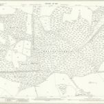
Hampshire & Isle of Wight XXVII.NW - OS Six-Inch Map
1908
Ordnance Survey
1:11k

Hampshire & Isle of Wight XXVII.NW - OS Six-Inch Map
1908
Ordnance Survey
1:11k

Hampshire & Isle of Wight XXVII.NW - OS Six-Inch Map
1894
Ordnance Survey
1:11k
Hampshire and Isle of Wight XXVII.2 (includes: Tunworth; Upton Gray; Weston Corbett; Weston Patrick) - 25 Inch Map
1909
Ordnance Survey
1:3k
Hampshire and Isle of Wight XXVII.2 (includes: Tunworth; Upton Gray; Weston Corbett; Weston Patrick) - 25 Inch Map
1894
Ordnance Survey
1:3k

Hampshire & Isle of Wight XXVII.SW - OS Six-Inch Map
1909
Ordnance Survey
1:11k