Cataloged map
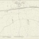
Wiltshire XIV.6 (includes: Brinkworth; Dauntsey) - 25 Inch Map

Institution:National Library of Scotland
Full title:Wiltshire XIV.6 (includes: Brinkworth; Dauntsey) - 25 Inch Map
Depicted:1922
Pubdate:1923
Publisher:Ordnance Survey
Map scale:1:2 500
An improved map of Wilt Shire
1755
Bowen; Tinney
Wiltonia sive comitatvs Wiltoniensis; anglis Wil Shire
1646
Blaeu
n/a
1742
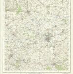
Salisbury - OS One-Inch Map
1956
Ordnance Survey
1:63k
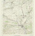
Swindon - OS One-Inch Map
1961
Ordnance Survey
1:63k

Marlborough (Hills) - OS One-Inch Revised New Series
1902
Ordnance Survey
1:63k

Marlborough (Outline) - OS One-Inch Revised New Series
1896
Ordnance Survey
1:63k

Devizes (Outline) - OS One-Inch Revised New Series
1896
Ordnance Survey
1:63k

Devizes (Hills) - OS One-Inch Revised New Series
1896
Ordnance Survey
1:63k

Salisbury (Outline) - OS One-Inch Revised New Series
1897
Ordnance Survey
1:63k