خريطة مفهرسة
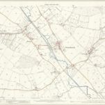
Herefordshire XXXVIII.1 (includes: Peterchurch; Vowchurch) - 25 Inch Map

المؤسسة:National Library of Scotland
العنوان الكامل:Herefordshire XXXVIII.1 (includes: Peterchurch; Vowchurch) - 25 Inch Map
مصورة:1886
تاريخ النشر:1887
الناشر:Ordnance Survey
مقياس الخريطة:1:2 500
An accurate map of Hereford Shire
1755
Bowen; Tinney
Herefordia comitatvs
1646
Blaeu
n/a
1742
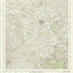
Hereford - OS One-Inch Map
1944
Ordnance Survey
1:63k
New map of the county of Hereford, 1
1754
s.n.
New map of the county of Hereford, 2
1754
s.n.
New map of the county of Hereford, 4
1754
s.n.
New map of the county of Hereford, 3
1754
s.n.

Hereford (Hills) - OS One-Inch Revised New Series
1897
Ordnance Survey
1:63k

Hereford (Outline) - OS One-Inch Revised New Series
1897
Ordnance Survey
1:63k