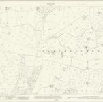
Cataloged map
Anglesey XVII.2 (includes: Llanfaelog; Llanfair Yn Neubwll; Llechylched) - 25 Inch Map

Institution:National Library of Scotland
Full title:Anglesey XVII.2 (includes: Llanfaelog; Llanfair Yn Neubwll; Llechylched) - 25 Inch Map
Depicted:1923
Pubdate:1924
Publisher:Ordnance Survey
Map scale:1:2 500

Holyhead (Outline) - OS One-Inch Revised New Series
1898
Ordnance Survey
1:63k

Holyhead (Hills) - OS One-Inch Revised New Series
1898
Ordnance Survey
1:63k
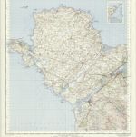
Anglesey
1630
Mercator; Hondius
Anglesey
1630
Mercator
Anglesey
1606
Mercator; Hondius
Anglesey - OS One-Inch Map
1948
Ordnance Survey
1:63k

Carnarvon (Outline) - OS One-Inch Revised New Series
1898
Ordnance Survey
1:63k

Carnarvon (Hills) - OS One-Inch Revised New Series
1898
Ordnance Survey
1:63k
n/a
1791
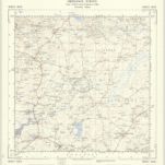
SH38 - OS 1:25,000 Provisional Series Map
1949
Ordnance Survey
1:25k