المشروع
المجتمع
الأخبار
تطبيقي
خرائطي
خرائط لينثيكوم (ماريلند)
بحث متقدم
الكل
خاص
المفضلة
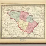
Howard.
1866|Martenet, Simon J.
1:221 760
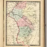
Anne Arundel.
1866|Martenet, Simon J.
1:221 760
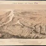
Map of the Seat of War: Washington, Baltimore, Harper's Ferry and Annapolis
1861|L. Prang & Co.
Bird's eye view of part of Maryland, Distr of Columbia and part of Virginia
1861|Bachmann, John
Strategic War Points of the United States no.1: Country Road Washington
1861|J. Wyld
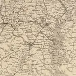
The new war map of Maryland, part of Virginia & Pennsylvania
1863|Russell, B. B. (Benjamin B.)
1:520 000
National Road from Washington to Lake Ontario
1828|Stansbury, A.J.
1:316 800
1600
1650
1700
1750
1800
1850
1900
1950
2000
التاريخ
الخرائط القديمة لـ لينثيكوم (ماريلند)
اكتشف ماضي لينثيكوم (ماريلند) على الخرائط التاريخية
الخرائط القديمة لـ لينثيكوم (ماريلند)
اكتشف ماضي لينثيكوم (ماريلند) على الخرائط التاريخية
استكشاف الخرائط
اكتشف التاريخ
المنطقة الأم
آن أروندل كاونتي
الأماكن ذات الصلة
© MapTiler
© OpenStreetMap
 1866|Martenet, Simon J.1:221 760
 1866|Martenet, Simon J.1:221 760
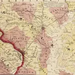 1861|L. Prang & Co.
 1861|Bachmann, John
 1861|J. Wyld
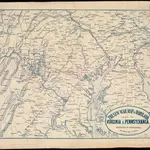 1863|Russell, B. B. (Benjamin B.)1:520 000
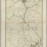 1828|Stansbury, A.J.1:316 800